Last Friday I left Guadalajara at 4pm after spending four days with 90 sixth graders at a camp outside of Guanajuato. I was tired, but I knew that one of the other two teacher/climbers would be able to drive the 7 hours to Mexico City. Scott and Swiggum were excited to have their second chance at a big mountain after last year on the Pico de Orizaba.
 |
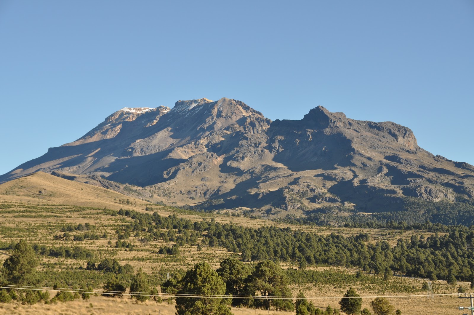
| Iztaccihuatl from the Paso de Cortes |
In D.F. (Distrito Federal a.k.a. Mexico City) we stayed in La Condessa, one of the hip neighborhoods. We enjoyed our last hours of civilization before driving from 7,500ft in D.F. up to 12,200ft. 12,200 ft is the elevation of the Paso de Cortes. In 1519 Hernan Cortes and his conquistadors crossed here between the volcanoes of Iztaccihuatl and Popocatepetl to get their first look at the lake of Tenochtitlan, the capital of the Aztec empire and soon to be capital of New Spain.
 |
| Sketch of the west side of Iztaccihuatl |
Without anywhere to stay the nice people at the visitor center let us camp out for the next two nights on their floor for 2 dollars a night. We spent the next day acclimitizing to 12,000 ft and above by hiking around the foot hills of Iztaccihuatl, the Nahuatl word for 'white woman'. Iztaccihuatl looks like a sleeping woman from the west or east. In fact, the names of the climbing routes and features refer to the anatomy of the sleeping woman.
 |
| Sleeping in the visitor center at the Paso de Cortes (12,200ft) |
On Monday morning we set out from La Joya (12,800ft) to the Refugio (a shelter built about 30 years ago by the Grupo de los Cien climbing club of D.F.). We carried all our food, water, sleeping supplies up to 15,500ft to stay the night with the plan of summitting the following day. As the night fell at the Refugio we ate tuna sandwiches for dinner and set up our sleeping bags in the silver lunch box shelter.
 |
| The Refugio 'El Grupo de los Cien' at 15,500ft |
 |
| Ascending just outside of La Joya |
 |
| Near the Portillo before Los Pies (the feet) |
As soon as I laid down for sleep I began feeling signs of AMS (Acute Mountain Sickness). My head started pounding, my body was gripped with extreme nausea and spinning, and overall weakness. I knew that if we went down it meant the summit would be out of the picture for me and Scott and Swiggum. I also knew I couldn't risk going up any further. I laid there for another 2 hours and the symptoms continued to worsen. This was only the second time I had experienced AMS, the first time was on Mt. Hood 3 years ago.
At 9pm the decision was made to go down. We picked our way back down from the Refugio back down to La Joya using the light from our headlamps. Back down at 12,800ft I immediately began to feel better. We slept for 5 hours in the car and then descended down to the town of Amecameca at the base of the volcanoes.
We were tired and defeated. There was a sense of disappointment among us and I felt guilt for being the reason we had to descend. We checked into a hotel in Amecameca and began pondering our options. I had no intention of returning to Guadalajara being utterly defeated. So I threw out the idea of going for a single push for the summit on Thursday. The guys looked disgusted. We had just spent three restless nights up there. Scott, a intense athlete, responded that if we went up Wednesday, meaning no sleep at low altitude, he would do it.
 |
| View of Iztaccihuatl from our hotel in Amecameca |
The decision was made that Scott and I would attempt a single push for the summit at 2am Wednesday morning. So we rested a couple hours in Amecameca and drove the Geo Prizm back up to La Joya for the night. That night we watched 'Lars and the Real Girl' on Scott's iPod before sleeping for five hours in the car again for our early morning wake up.
My watch alarm woke us up at 2am and we threw on our clothes and packs and started trudging up and waiting for the sun to hit us. We reached the Refugio at 15,500ft by 5am. The sky was still black and the stars shined brightly above the city lights from Mexico City to the west and Puebla off to the east. We gathered ourselves and then began the ascent of Las Rodillas (the knees). Las Rodillas was a time consuming class 2-3 rock climb to 16,300ft. Scott, having never done any rock climbing before, felt extremely exposed through this section.
 |
| Pico de Orizaba at sunrise |
 |
| Popocatepetl erupting beyond the Paso de Cortes |
The sun hit us about 20 minutes from the summit of Las Rodillas. Popocatepetl began throwing out puffs of black smoke as the sun lifted from behind Pico de Orizaba out in the distance. The orange sunrise gave us new energy as we arrived at the top of the knees and looked out at the arctic landscape in front of us.
 |
| Crossing the Glacier de Ayoloco |
From Las Rodillas there are 3 hours of traversing, ascending, descending amongst snowy ridges, glaciers, and steep rock faces. We crossed La Barriga (the belly) which contained the melting Glacier de Ayoloco. The mix of climbing forced us to put-on and take-off our crampons 3 times before attaining the summit ridge (La Arista del Sol) near 17,000ft. The summit (17,180ft) turned out to be a snow bowl with three separate 'summits'. We picked the one that appeared to be a meter or two taller than the others and lethargically trudged onwards.
 |
| The summit (17,180ft), El Pecho (the breast), third tallest mountain in Mexico (Orizaba is tallest, Popocatepetl is second) |
At the summit we snapped a couple photos, hugged, and then began the long descent back. As we came back down Las Rodillas the clouds began rolling in from the east like clockwork at noon. We carefully worked our way down the section traversing Los Pies (the feet) and back down to La Joya. We reached the car at 3pm, making the entire day a 12.5 hour day with very few breaks.
 |
| Scott and Sam at summit overlooking La Cabeza (the head) |
A 3.5 minute video from climbing Iztaccihuatl:
YouTube link for Iztaccihuatl from Guadalajara


No comments:
Post a Comment